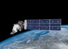
Landsat 9 is an Earth observation satellite launched on 27 September 2021 from Space Launch Complex-3E at Vandenberg Space Force Base on an Atlas V 401 launch vehicle
NASA is in charge of building, launching, and testing the satellite, while the United States Geological Survey (USGS) operates the satellite, and manages and distributes the data archive.
This current satellite is the ninth in the Landsat program, which is the longest-running enterprise for acquisition of satellite imagery of Earth.
Landsat is a joint NASA / USGS program. The satellites are used as a resource for global change research and applications in agriculture, cartography, geology, forestry, regional planning, surveillance and education, and can be viewed through the U.S. Geological Survey (USGS) “Earth Explorer” website.
On 23 July 1972, the Earth Resources Technology Satellite was launched. In 1975 was renamed Landsat 1 in 1975.
Source: NASA

Rod is a blogger, writer, filmmaker, photographer, daydreamer who likes to cook. Rod produces and directs the web series, CUPIC: Diary of an Investigator. He is also the editor, producer and administrator of STM Daily News, a part of the TNC Network.
