Damaging flooding is predicted to be common along most coasts by 2030
Coastal communities across the U.S. saw record-setting high-tide flooding last year, forcing residents to deal with flooded shorelines, streets, and basements — a trend that is expected to continue into 2022 and beyond without improved flood defenses, according to a new NOAA report. High waters are affecting coastal economies and crucial infrastructure like waste and stormwater systems and roads.
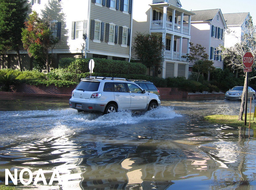
High-tide Flooding
The report, 2021 State of High Tide Flooding and Annual Outlook, documents changes in high-tide flooding patterns from May 2020 to April 2021 at 97 NOAA tide gauges along the U.S. coast, and provides a flooding outlook for these locations through April 2022, as well as projections for the next several decades.
High-tide flooding, often referred to as “nuisance” or “sunny day” flooding, is increasingly common due to years of sea level rise. It occurs when tides reach anywhere from 1.75 to 2 feet above the daily average high tide and start spilling onto streets or bubbling up from storm drains. As sea level rise continues, damaging floods that decades ago happened only during a storm now happen more regularly, such as during a full-moon tide or with a change in prevailing winds or currents.
According to the report, U.S. coastal communities saw twice as many high tide flooding days than they did 20 years ago — and the trend of near-record high tides is expected to continue through April 2022, as well as in decades to come. Along the Southeast Atlantic and Gulf coastlines, 14 locations set or tied records where rapidly increasing trends in high-tide flooding have emerged.
“NOAA’s tide gauges show that 80% of locations where we collect data along the Southeast Atlantic and Gulf coast are seeing an acceleration in the number of flood days,” said Nicole LeBoeuf, director of NOAA’s National Ocean Service. “High-tide flooding disrupts people’s lives when they can’t get to and from work or have to repeatedly deal with a flooded basement. NOAA is committed to working with coastal communities to provide the information and tools they need to tackle the problem of high-tide flooding, both now and in the coming years as sea levels continue to rise.”
NOAA’s water level records highlight regions of particular concern in Texas and Florida, with records also broken along the coasts of South Carolina and Georgia. From May 2020 to April 2021, Galveston, Texas; Corpus Christi, Texas; and Bay Waveland, Mississippi set a record of more than 20 days of high tide flooding. These locations would typically only flood 2-3 days each year 20 years ago. Dauphin Island, Alabama; Grand Isle, Louisiana; Pensacola, Florida; Trident Pier, Florida; Charleston, South Carolina; Port Isabel, Texas; Rockport, Texas; and Panama City Beach, Florida all saw between 10 and 20 days of flooding. In 2000, these locations typically saw between 0-2 days of high tide flooding. Data specific to each NOAA tide gauge included in the report can be found here.
“High tide flooding is becoming common and damaging in many parts of the U.S.,” said William Sweet, Ph.D., an oceanographer for NOAA’s National Ocean Service and lead author of the report. “Many coastal communities are saddled with this problem, so NOAA is working to provide them with the kinds of information needed to anticipate, prepare for, and respond to increasingly frequent high tide flooding.”
Sweet and his co-authors project that from May 2021 to April 2022, the national high tide flood frequency is expected to continue to accelerate, with U.S. coastal communities seeing on average 3 to 7 days of flooding in the coming year, as compared to 2-6 days projected just last year. Regionally, locations along the Atlantic and Gulf coasts may experience even more days of flooding each year.
By 2030, long-term projections show 7-15 days per year of high-tide flooding for coastal communities nationally. By 2050, that rises to 25-75 days. These long term outlooks are based on the range of relative sea level rise, using two scenarios of the Fourth National Climate Assessment considered more likely to occur by 2030 and 2050 – Intermediate Low and Intermediate.
NOAA maintains ocean observing infrastructure, including more than 200 permanent water level stations on the U.S. coasts and Great Lakes, and is the nation’s authoritative source for historic and real-time data, forecasts, predictions, and scientific analyses that protect life, the economy, and the environment on the coasts.
2021 HTF Report and Outlook Press Call
Source: NOAA
https://tnc.network/knowledge/
https://tnc.network/knowledge/
